#EUSpace

The Group on Earth Observations (GEO) is a voluntary partnership of governments and organisations that envisions "a future wherein decisions and actions for the benefit of humankind are informed by coordinated, comprehensive and sustained Earth observations and information".
The Human Planet is an initiative in the GEO 2017-2019 work programme supporting the GEO Strategic Plan 2016-2025. The Human Planet aims to support novel evidence-based assessment of the human presence on the planet Earth. The Human Planet leverages on advances of Earth Observation technologies and geo-spatial data analytics for improving the global awareness on the spatial patterns and processes of the today’s urbanizing world.
New open, inclusive and consistent data are needed for assessing humanity’s impact on the planet, access to resources, and exposure to risk. New knowledge is needed in order to translate these new data into actionable information to support decision making by governments, organizations and individuals.
The Human Planet Initiative involves more than 150 individual scientists and policy makers belonging to 85 different organisations including academies, international stakeholders, governmental bodies and the private sector.
A number of expert groups has been established to address specific thematic areas of the Human Planet.
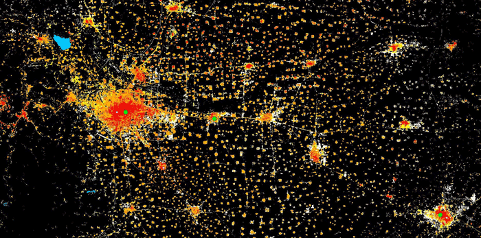
The Human Planet initiative generates global datasets including the built environment and density of population over time.
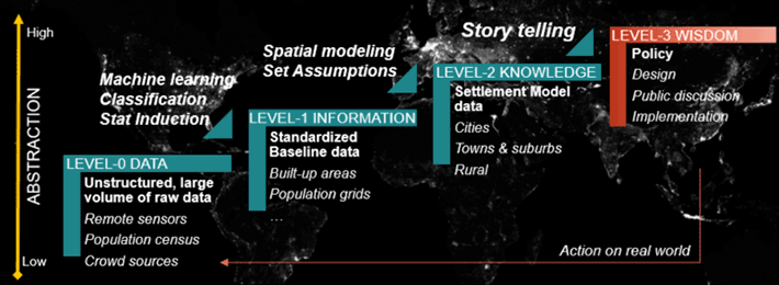
The Human Planet Intiatives works closely with decision makers, scientists and technologists. The aim is to make data useful for scientists and policy makers.
The HPI processes large volume of satellite imagery to extract useful societal information, combines the information to generate new information and provides on demand analysis for policy makers.
The Human Planet Intiative focuses on understanding cities and settlements, their resilience to hazards impact, their environmental sustainability and quality of life.
The HPI data are also used to assess societal impact on the biosphere, land and atmosphere. HPI generated information are used by scientist, policy makers and to report on the post 2015 international Framework Agreements.
The figure shows in background planet Earth as we see it from space with superimposed a conceptual Earth System Science diagram with its main subcomponents.
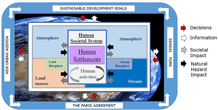
The biannual editions of the Atlas of the Human Planet provide a summary of HPI activities. Each issue addresses one or more societal benefit areas as put forward by GEO that link to:
New Urban Agenda, 2030 Sustainable Development Agenda, the Sendai Framekwork for Disaster Risk Reduction and The Paris Agreeement.
Atlas of the Human Planet 2020 - Settlement pattern and processes. The Human Planet Atlas 2020 reviews the many applications addressed using HPI data. The applications are grouped based on development, disaster risk, urbanisation and climate impact.
Atlas of the Human Planet 2019 - How is the world urbanising? Based on the New Degree of Urbanisation – a method endorsed by the United Nations method to maps cities and settlements - the Atlas of the Human Planet 2019 provides a first standardized assessment of urbanisation globally.
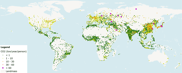
Atlas of the Human Planet 2018 - Enumerating and sizing cities of the world. The report also summarizes key features from over 10.000 cities world wide, including CO2 emissions.
Atlas of the Human Planet 2017 - Quantifying exposure to hazard impact. Is risk to hazard impact increasing? The Atlas highlights the increase in exposure for five major hazards.
Atlas of the Human Planet 2016 - Quantifying built-up and population growth over time. How have cities and settlements grown from 1975 to 2015? The Human Planet Atlas 2016 is the first global overview of urbanisation specifically targeting the themes set forward in the New Urban Agenda.